The 4th day of our Saxon Trek was the longest one and marked passing from the Hârtibaciu Valley to the Târnavelor Plateau which is also known as the „Weinland”. Villages like Biertan, Richiș and Saroș were famous for the terraced vineyards they had and for the local wine they produced called “Neuburger”. We walked 26 kilometers from Dealu Frumos to Mălâncrav.

As we knew that we would have a long day ahead, we woke up very early and left Dealu Frumos in the direction of Stejărişu. The way to Stejărişu (about 8 km) was half on the main national road as there was no forest path to chose, but still it was early enough to meet only a few cars and enjoy the silence around. We did pass of course, by a farm where the not so friendly dogs welcomed us with loud barking and angry faces. Luckily, we managed to calm them down, we gave them some pieces of bread and they let us pass by. After this, we considered it’s a good idea to always have bread on hand for the dogs. You never know when you need it.

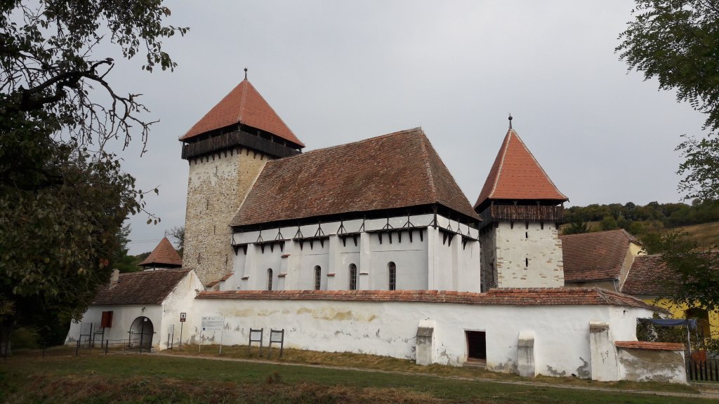
We found Stejărişu quiet, with just a couple of people showing up on the streets for their morning routine and tasks. We stopped for a couple of minutes to chat with a local and then headed to the center of the village, the fortified church.


We had a pleasant walk through the village admiring the Saxon houses and the church. People say that it’s a wonder that this village still exists, as it was not easy for the first settlers to build a community and a village here. In the XIII century the German colonists settled in the area. They built houses, started to work the land and built a church. After heavy flooding, the village was destroyed and the locals had to move their houses a few kilometers upstream. In those times, the Otomans would attack, the Saxon noble and the Sibiu Parrish would also fight for the land, but still the locals kept to their lands and houses and refused to move out. After 600 years, the village and its church are still there, standing still.


In Stejărişu a small fortified church has been very well preserved. After the original building and the surrounding village had to be abandoned due to heavy flooding, the construction of the new church began in the XIV century. Right on the bank of the Hârtibaciu river, the foundations of a church were discovered, which attest the historical location of the initial village.


A few kilometers away, on a small hill in the center of the village, the new church was built, and surrounded by two fortification walls. The two defensive towers provided additional protection. In the XIX century, the growing community demolished the inner wall of the fortification and used the stones to extend the church. Due to extensive repair work, the fortification is in a good state of preservation today.

Close to the church, across the small river passing through the village, we saw a very nice house and we decided to have a closer look. We were happy to see that this is the Agramonia rural guesthouse and it was also breakfast time. Although we already had a breakfast at the start of our journey, we decided to have some traditional zacusca and other homemade stuff they had there. We enjoyed our second breakfast and the morning coffee in their backyard, surrounded by some very friendly farm animals.


Energized, satiated and with our pockets full of nuts from Agramonia, we continued our trip in the direction of Mălâncrav, our final destination for the day, which was about 18 kilometers away. From Stejărişu we mostly had marked trails that we followed, which helped us a bit with better finding our way from one village to another (red cross path ![]() ). Sometimes the marking was not visible and we would walk in circle for some minutes before finding it again, but overall, it proved quite helpful to see a sign on trees from time to time.
). Sometimes the marking was not visible and we would walk in circle for some minutes before finding it again, but overall, it proved quite helpful to see a sign on trees from time to time.


From Stejărişu the path took us on a hill outside the village and then through pastures and forests until reaching the hill over Mălâncrav. It was quite a long, but naturally beautiful walk, with tall trees and the highlands showing us their best. It was one of the most beautiful parts from all our journey.


Of course we met some angry shepherd dogs, but we passed them by without any issues. The new experience for the day was that somewhere on the way to Mălâncrav, we came across some bear tracks that got me very scared. People that we met during our trip kept saying that there are bears in the forests that we planned to pass, but until seeing these tracks we kept thinking it’s just a way of them making funny jokes and trying to scare us. Too bad their jokes came out to be true. We hurried to get out of the forest and get to the village as soon as possible.


Relieved to see the village in the valley below us, we had a small snack and relaxed while drinking a beer we took from Agramonia. We went down towards the village passing one of the many apple orchids Mălâncrav is famous for.


We got to Mălâncrav in the afternoon, just before a light rain would start. We had a walk around the village and visited the fortified church and the Apafi Manor. The Manor has been receiving guests since 2007. In 2000, with the help of the local community, Mihai Eminescu Trust took over the decayed building, previously owned by the state during the Communist period, and started an ample process of recovery.


The Mălâncrav Romanesque church, conceived as a three-naved basilica, was built by the villagers at the beginning of the XIV century and dedicated to Saint Mary.


The twenty-meter fresco in the central nave is the largest and most thematically complete Gothic fresco in Transylvania. Fifty-three images are grouped in four rows and in the spaces between the arched passageways. In the XIX century, the central naval fresco were painted over. They have been brought back to light during a renovation in 1914, but remained partially damaged by this process. The fresco that covered the choir area were kept mostly intact. They are believed to represent the international Gothic style from the Royal Courts. Presently, the evangelistic community in Mălâncrav has 150 members who preserve some of the old Saxon traditions. Despite their small number, there are weekly gatherings of all ages, and the community remains an active one.


The Mălâncrav village came into being in the year 1305; to this day, it has a larger Saxon population than any other Transylvanian village. In 1340, the settlement and land around it become the property of the Apafi family, which ruled Transylvania up until the 17th century. During the 18th century, the village was transferred to the Hungarian royalty, having been granted to them by decree of the king. The last owner of the village was the countess Susanne Haller. During this time, there was only one brick house outside the noble residency, the rest of the houses being wood or clay. This led to the destruction of more than two-thirds of the village in a terrible fire, forcing the people to rebuild their houses out of bricks. In 1865, the English writer Charles Boner would note that all the house “look solid and radiate a comfortable prosperity.”


Although it was very cloudy and a bit raining during our stay in Mălâncrav, we still got to enjoy the streets, the beautiful houses and the quiet this village has to offer. Especially since there is not too much network coverage, so mobile phones are not distracting us from a true rural experience. We spent the night in one of the beautifully restored houses, a project of Mihai Eminescu Trust. The lady taking care of the house prepared a nice dinner with local ingredients, paired with some house wine, just what we needed after such a long day.


A list of all the available accommodation in the village can be found HERE.
Here is our map for the day.


Leave a comment